

- Srinagar Tour
- Gulmarg Tour
- Sonmarg Tour
- Patnitop Tour
- Jammu Tour
- Katra Tour
- Kargil Tour
- Leh Tour
- Yusmarg Tour
- Lesser Known Places
Tour Packages


 Kargil :
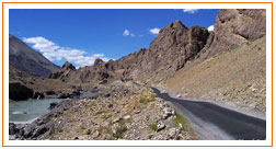
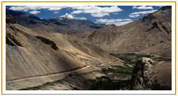
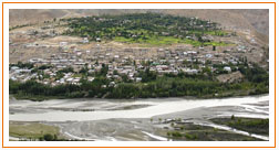
is a district of Ladakh, Kashmir, India. Kargil lies near the Line of Control facing Pakistan-administered Kashmir's Baltistan to the west, and Kashmir valley to the south. Zanskar is part of Kargil district along with Suru, Wakha and Dras valleys. Kargil was at the center of a conflict between India and Pakistan in 1999. Kargil district is nestled in the Himalayas, giving it a cool, temperate climate. Summers are warm with cool nights, while winters are long and cold with temperatures often dropping to -40 °C (-40 °F) with recorded
Kargil :
is a district of Ladakh, Kashmir, India. Kargil lies near the Line of Control facing Pakistan-administered Kashmir's Baltistan to the west, and Kashmir valley to the south. Zanskar is part of Kargil district along with Suru, Wakha and Dras valleys. Kargil was at the center of a conflict between India and Pakistan in 1999. Kargil district is nestled in the Himalayas, giving it a cool, temperate climate. Summers are warm with cool nights, while winters are long and cold with temperatures often dropping to -40 °C (-40 °F) with recorded
 temperatures of -60 °C (-76 °F) in the tiny town of Dras, situated some 56 km (35 mi) from the Kargil town. The Zanskar plateau is even colder, making it thus a near-uninhabitable place for humans, except
for the hardy Khampas. The entire Kargil district is spread over 14,086 km2 (5,439 sq mi). The Suru River flows through the district.National Highway 1D, connecting Srinagar to Leh, cuts through Kargil.
temperatures of -60 °C (-76 °F) in the tiny town of Dras, situated some 56 km (35 mi) from the Kargil town. The Zanskar plateau is even colder, making it thus a near-uninhabitable place for humans, except
for the hardy Khampas. The entire Kargil district is spread over 14,086 km2 (5,439 sq mi). The Suru River flows through the district.National Highway 1D, connecting Srinagar to Leh, cuts through Kargil. This highway is typically open for traffic only from June to mid-November due to heavy snowfall at the Zoji La, but in recent years it has been opened before June. Kargil is located 204 km (127 mi) from the capital city of Srinagar. There is a partially paved road-the first 40 kilometres (25 mi) or so-leading from Kargil south to Zanskar. Total distance to Zanskar is nearly 220 km (140 mi), which is again open only from June to September. The region has recently been opening to tourists, with steps a travel hub by the Indian
 Government. Recently, both India and Pakistan have considered linking the Pakistan town of Skardu with Kargil via a bus route to facilitate free movement of Kashmiris in the area.
Suggested Tours
- Srinagar - Mughal Garden - Gulmarg (2 Nights 3 Days).
- Srinagar - Gulmarg (3 Nights 4 Days)
- Srinagar - Gulmarg - Pahalgam (4 Nights 5 Days)
- Srinagar - Mughal garden - Gulmarg - Pahalgam (4 Nights 5 Days)
- Jammu - Patnitop - Katra Mata Vaishnodevi - Shivkhodi (5 Nights 6 Days)
- Cultural Ladakh Tour (05 Nights 06 Days)
- Srinagar - Mughal Garden - Gulmarg - Pahalgam - Sonmarg (6 Nights 7 Days)
- Gulmarg - Pahalgam - Srinagar - Sonmarg - Kargil - Leh (12 Nights 13 Days)

Car Rentals Across North India
copyright © 2012-2013,Real Paradise Journey, All Rights Reserved Web Design: Futuristic Software
Futuristic Software